|
|
Post by threadworm on Mar 20, 2011 16:48:50 GMT -4
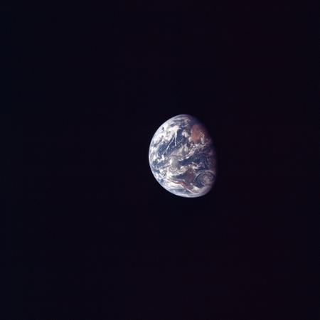
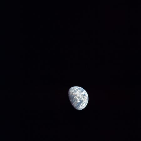
For my first contribution, here's something I posted yesterday on another forum to counter the whole "It was filmed in low earth orbit and the earth they used was a photo stuck on the window" routine. Whole earth images would have been possible thanks to the ATS series of satellites (ATS3 was up there at the time at about 22000km). However here is an image taken by Apollo 11 on July 16th as it journeyed to the moon:  I've never bothered to watch the 'A funny thing happened on the way to the moon' video, but I'm told it matches exactly with the footage used in that. Also around in the sky on July 16th was ESSA: science.nasa.gov/missions/essa/ESSA very kindly took a photo of Hurricane Bernice, off the coast of Central America on July 16, which by then had turned into a Tropical depression:  You can find the photos recorded here: docs.lib.noaa.gov/rescue/mwr/098/mwr-098-04-0280.pdfIf you zoom into the Apollo 11 photo and overlay the storm onto it you get this:  There are other tropical storms around at the time of the mission (Hurricane Anna and Tropical Storm Claudia), but while there are images that suggest their presence, there are no exact matches. You can also find the weather maps of the US at the time: docs.lib.noaa.gov/rescue/dwm/data_rescue_daily_weather_maps.htmlAnd it's obvious that the cloud patterns match up with the pressure charts:  If anyone is more expert in the images available for other missions, it's worth googling for the hurricane season of the year of the mission - you usually get 2 (Eastern Pacific and Atlantic). Cyclone season also works: Tropical Cyclone Corinne was active during Apollo 12, but I haven't found any satellite images yet. As part of the same ongoing argument, I took 44 of the frames from Apollo 11's journey to the moon, oriented them so that they were all the right way up and stretched them so that they remained the same size: img695.imageshack.us/img695/3294/30f.mp4Thanks for listening  |
|
|
|
Post by grashtel on Mar 20, 2011 17:22:06 GMT -4
Nice work, but in this thread (which is also stickied at the top of this section) Count Zero beat you to it. |
|
|
|
Post by LunarOrbit on Mar 20, 2011 17:46:21 GMT -4
It's good to see that someone else independently reached the same conclusion as Count Zero.
|
|
|
|
Post by capricorn1 on Mar 20, 2011 18:04:18 GMT -4
Nice work, but in this thread (which is also stickied at the top of this section) Count Zero beat you to it. I don't think he did.....can you show me in that thread where it does that Hurricane Bernice matchup? That is very impressive, what did the HBs say about it on your forum? Which forum btw? |
|
|
|
Post by graham2001 on Mar 20, 2011 20:45:25 GMT -4
Congratulations, you've independently taken Count Zero's work to the next level, people tend to think of the Apollo program in a vacuum and forget that other spacecraft with cameras were in orbit at the same time.
|
|
|
|
Post by Count Zero on Mar 20, 2011 21:10:36 GMT -4
Excellent work! I hadn't known where to find archival satellite weather photos from that far back. I especially liked the way you integrated the sat photo with the Apollo pic.
Perhaps we can merge this with the other thread so that it all stays sticky at the top?
|
|
|
|
Post by LunarOrbit on Mar 20, 2011 23:26:44 GMT -4
Perhaps we can merge this with the other thread so that it all stays sticky at the top? I made it a sticky thread instead of merging it with the other thread. I didn't want Threadworm's hard work to be buried at the end of a 30+ page thread because HBs would lose interest before getting to it. |
|
|
|
Post by threadworm on Mar 21, 2011 1:29:49 GMT -4
I'm flattered!
I posted it originally on Icke's forum - I went to town on the weather photos after my posting of the rotation video was ignored by HBs.
Here is the response of the HBs to my analysis:
" "
It's almost as if they don't want to see it!
It would be nice to repeat the exercise for other missions, as there usually seems to be a recorded storm system of some sort somewhere, but finding coincident images is tricky.
|
|
|
|
Post by lukepemberton on Mar 21, 2011 5:03:42 GMT -4
Welcome to the board, and after that intial post take the flattery. You deserve it. It rather blows away the transparency theory. However, expect a fourteen hour long video series from a certain antipodean that points out that you are wrong  Get used to that. They don't know what the scietific method is. They have their conclusions, and will cherry pick and mine data that supports their ideas. My focus is on radiation, and once you dig into their claims, you realise they use some of the worst solar proton events in history to support their theories. Show them something solid, and they either ignore it, reinvent physics or move the goal posts. As a general rule, they aren't that honest. |
|
|
|
Post by threadworm on Mar 21, 2011 17:04:01 GMT -4
And so the detective work continues, and I believe I may have hit paydirt. Thanks to a serendipitous link to www.moonviews.com that mentioned an archive of old satellite sata, I was able (eventually!) to find this page: www.lib.noaa.gov/collections/TIROS/tiros_2.htmlOn it there are lots of documents (some of them quite substantial) with old satellite images, and quite a few cover Apollo mission dates. One of them - a catalogue of ESSA 9 images (BIG file!): docs.lib.noaa.gov/rescue/TIROS/Z6685U64no5-324.pdfhas on page 120, a southern Hemisphere shot from November 15th 1969. Here's the screenshot of it:  Here is a shot taken of the earth from Apollo 12:  It was taken around the 15h of November or thereabouts in Trans Lunar Coast. Now look at them next to each other. I've rotated the apollo 12 shot to make it easier:  The red lines show some obvious weather feature matches  Interestingly, the Apollo Image library suggests the terminator is Western Australia, when actually it is much nearer Chile. Go to work people  |
|
|
|
Post by grashtel on Mar 21, 2011 18:25:01 GMT -4
Please can you replace the huge image with a link or smaller version so as to not break the forum for people without big wide screen monitors.
|
|
|
|
Post by ka9q on Mar 22, 2011 6:22:02 GMT -4
Nice work! You should consider contributing it to the editors of the Apollo Flight Journal (http://history.nasa.gov/afj).
I think they would be particularly interested in any corrections to errors you might find in the photo captions.
|
|
|
|
Post by threadworm on Mar 22, 2011 17:12:46 GMT -4
Thanks  But wait...there's more: Back in the 1960s, when weather satellites were a new toy, many people worked on matching orbital observations with those derived from ground based data such as radar. One such researcher was the author of this 1971 MIT masters thesis: dspace.mit.edu/bitstream/handle/1721.1/59623/30119849.pdf?sequence=1The author looked at satellite images from the Caribbean's BOMEX dataset, and compared them with data from the ground. Those satellite images cover the period of Apollo 11's flight. Let's see what they produce: This image (AS11-36-5361):  With the craft on the way to the moon having discarded the final Saturn stage and docked with the LM. Here is an ESSA 9 satellite image of the Caribbean taken on July 17th:  (the annotations are the original author's) The high resolution version of the apollo image allows us to zoom in on the Caribbean. We can then superimpose the satellite image on it:  On July 18th, roughly 55 hours into the mission, this photograph was taken (AS11-36-5381):  The remainder of this magazine show images Aldrin in the LM, and then the lunar surface. Here is the ESSA 9 image of the Carribean for the 18th:  (the annotations are the original author's) If we rotate the apollo image so that it is the right way up, then superimpose the ESSA 9 image we get this:  On the way home from the moon, Magazine 38 was used to take photographs of the receding moon and approaching Earth. The first image of Earth on that magazine is AS11-38-568:  I'd put this image at half way home - the 22nd of July. Here's the ESSA 9 image from that date:  (the annotations are the original author's) and here is the superimposed ESSA/Apollo image.  You can draw your own conclusions as to how well these three sets of images match. |
|
|
|
Post by BertL on Mar 22, 2011 20:29:59 GMT -4
Amazing stuff, especially since these images come from 1973. I'm disagree with your assessment that the master thesis is from 1971. The front page says "May 1973", and some of the references are from after 1971. Apart from that, an excellent find.
|
|
|
|
Post by threadworm on Mar 23, 2011 1:23:23 GMT -4
Amazing stuff, especially since these images come from 1973. I'm disagree with your assessment that the master thesis is from 1971. The front page says "May 1973", and some of the references are from after 1971. Apart from that, an excellent find. lol - nothing like attention to detail  I hadn't read further down the page - his Bachelor of Science was in 1971, his Masters 1973! I have emailed NOAA to see if I can track down the missing chunk of photos from 1969 - I really want to nail the earthrise photos  |
|


