|
|
Post by Jason Thompson on Nov 18, 2009 9:49:06 GMT -4
 Does the landing site look flat and level to you, Andreas? |
|
|
|
Post by andreas on Nov 22, 2009 5:54:25 GMT -4
Does the landing site look flat and level to you, Andreas? As I have used “flat” in a way that there are no mountains with steep flanks, or if one classifies the landscapes in mountainous, fissured or flat, then I categorise it as flat: neither shaded nor brightly illuminated flanks of mountains are visible. I think the Sea of Tranquillity has been selected as landing site because it is flat in this sense. Holes (craters) with diameters up to about 300m are not relevant for the visibility of an observer (as long as he is not directly in a hole) and are therefore neglected – as they have been neglected for the selection of the landing site. If the overall inclination were estimated according to this picture then several tens of degrees margin would have to be applied. So the overall inclination has been estimated with help of a map. The map has also been used to check whether there are mountains higher than 1km. Andreas, here's a shot from the Apollo 11 EVA footage of Armstrong with his back turned to the camera. Would you say he looks upright and vertical in this image?  Being upright is no key element in the derivation of the Looking-down-to-the-sky effect. But I would say if the astronaut were fully upright his head could be maximum up to 40cm higher. Concerning the vertical direction: the astronaut is seen between “from the back” and “from the side”, a difficult perspective to judge his bearing and how he is walking. A whole video sequence would be much better, as I used it. But if this scene were one of the best from the NASA videos, I would take it as a reference for the vertical and horizontal directions, but with a tolerance of 200mrad (11°). This fixed-image would therefore be sufficient to see a possible big(?) tilt of the TV camera as you have indicated it (reply #96:” the TV camera is NOT horizontal with respect to the LM ... knowing full well that the camera is NOT level”): the camera is almost upside down, but – according to the training picture history.nasa.gov/alsj/a11/ap11-S69-31584.jpg – with an estimated tilt of 30° to 45°, and such a big tilt should be recognised even on the above fixed-image. When you said you knew how the camera is mounted (and tilted?), can you confirm that the training picture is representative and the 30° to 45° estimation is reasonable or have you other and better values? |
|
|
|
Post by gwiz on Nov 22, 2009 7:07:17 GMT -4
As I have used “flat” in a way that there are no mountains with steep flanks, or if one classifies the landscapes in mountainous, fissured or flat, then I categorise it as flat: neither shaded nor brightly illuminated flanks of mountains are visible. I think the Sea of Tranquillity has been selected as landing site because it is flat in this sense. No-one here is saying there are mountains, but you don't need mountains to undermine your argument, just a few small dips and rises will do the trick. If your viewpoint/camera is less than a couple of metres above the surface, then a rise of a metre or two is going to make an enormous difference to the closeness of the horizon. The material from a crater has to go somewhere, and a lot of it doesn't go very far, just far enough to give a raised area around the crater which will certainly affect visibility. |
|
|
|
Post by JayUtah on Nov 22, 2009 11:38:46 GMT -4
As I have used “flat” in a way that there are no mountains with steep flanks, or if one classifies the landscapes in mountainous, fissured or flat, then I categorise it as flat...Please tell us your geometric threshold for terrain variation, how you derived it, and how you mathematically proved that variations below your threshold would not affect your results. Then please show how you determined that no variations above your threshold were present in your images. neither shaded nor brightly illuminated flanks of mountains are visible.Please justify why illumination cues are, by themselves, a sufficient determinant of terrain variation in your photographs. Please explain how the limitations or properties of the various imaging systems affect your ability to detect variations visually by means of illumination. Further, have you ever seen anaglyphic representations of the surface of Mars? I think the Sea of Tranquillity has been selected as landing site because it is flat in this sense.But we are not talking about mountains and valleys so much as relatively small-scale terrain variations that may not be large enough to concern mission planners, but may be large enough to affect your results. Given the objective evidence of terrain variation as well as astronaut testimony to the variation of terrain orientation, I'd say you have a tremendous burden of proof to satisfy here. Holes (craters) with diameters up to about 300m are not relevant for the visibility of an observer...Craters are not composed merely of depressions relative to the surrounding mean surface level, but contain also "lips" and agglomerations of ejecta that contribute to the perception of the local terrain. Seen from a low height, these would create false horizons. But if this scene were one of the best from the NASA videos, I would take it as a reference for the vertical and horizontal directions...My mind still boggles that you would attempt to use the orientation of an astronaut as a reference for vertical. ...and such a big tilt should be recognised even on the above fixed-image.Circular reasoning. You are assuming such a tilt cannot have occurred because it seems inconsistent with your interpretation of the rest of the scene. However, that interpretation is based simply on assuming the visual horizon is essentially the theoretical horizon. You may not simply beg the question.
|
|
|
|
Post by theteacher on Nov 22, 2009 16:34:38 GMT -4
According to the Mission Report the landing site should rise 4.5° in direction West (shadow) and the LM should therefore be tilted 4.5° East. You say that according to the picture AS11-40-5928 (border of the ridge), which is taken about 10m from the LM, the ridge is therefore higher than the camera. For this picture the applied rise of the terrain looks perfect and seems to disprove my result of the Looking-down-to-the-sky effect. But your justification can only be applied to this picture, and when proceeding to another one, it can not be held any more: You can't be serious. The photo 5928 is taken within seconds from 5927 and 5929. I have made a small panorama by combining the three photos. In this case it's fairly easy, and you can see it here: i689.photobucket.com/albums/vv255/aawnn/pan272829.jpgSomeone has combined the three photos to an animation, which you can see here: www.hq.nasa.gov/alsj/a11/a11anim5927-9yk.gifIt is obvious, that the photos are taken a few seconds apart. As Armstrong moves away from the LM he takes another series of photos consisting of 5931-5941, which together make up a 360 degrees panorama. I have made a small panorama consisting of only 5930, 5931 and 5932, and you can see it here: i689.photobucket.com/albums/vv255/aawnn/pan303132.jpgIf you browse your way through magazine S from the Apollo 11 mission (link: www.lpi.usra.edu/resources/apollo/catalog/70mm/magazine/?40 ), you will see a lot of photos, that can be combined in the same manner, and I am not the only one, who has assembled the photos to panoramas in order to get an overview of the landing site. Have a look at a collection of numerous panoramas at The Apollo Surface Journal: www.hq.nasa.gov/alsj/a11/images11.html#PansExactly! Now let's examine this picture, which is a magnified, cropped and annotated version of one of the LRO-photos of the landing site. Take your time to get the interpretation right: 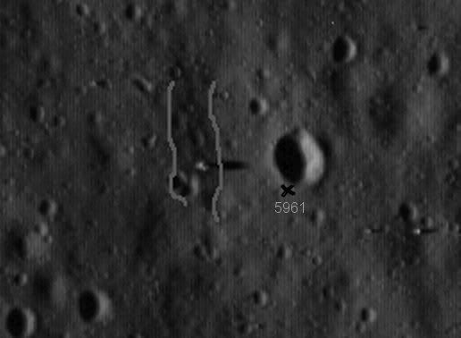 The photo is taken in the lunar evening, so that the sun is shining from the west (left), which is opposite to the Apollo 11 landing, which took place in the lunar morning, so that the sun was shining from the east (right). I guess that you will agree with me, that areas darker than average are sloping to the right (east) and that areas lighter than average are sloping to the left (west). When I called the landing spot a hillside, it was a rhetorical exaggeration to make my point clear(er), but nevertheless: The area between the two grey lines is somewhat darker than the areas both to the left and to the right, so it is reasonable to interpret this fact as a sloping of this part of the terrain to the right. If we now move to the spot marked with a cross, this place and its nearest surroundings are lighter than average, so it's reasonable to interpret this as a rise of the terrain again looking to the right. It can't be surprising though, as we have now climbed the rim of East Crater (or Little West or whatever), and it is from here 5961 is taken ( www.lpi.usra.edu/resources/apollo/frame/?AS11-40-5961 ), and compare this to the panorama presented in an earlier post: www.hq.nasa.gov/alsj/a11/a11pan1111231EvM.jpgSo as Armstrong returns from the crater to the LM, he descends the rise of the crater rim and crosses the shallow "valley" between the crater and the LM and finally over the last 10-20 meters ascends a couple of meters to the LM. So your describing the topography between the camera and the LM as "a plate" is close to what I see in the LRO-photo and the panoramas, except that I rather would describe it as closer to an elongated saddle-like structure. Compare for instance "your" photo 5928 www.lpi.usra.edu/resources/apollo/frame/?AS11-40-5928 with the adjacent photo 5929 www.lpi.usra.edu/resources/apollo/frame/?AS11-40-5929 . It's easy to see, that those two photos are tilted relative to one another, so to make the above mentioned panorama, it is necessary to rotate at least one of the photos several degrees. When you browse magazine S, you will see several examples of a tilted camera. Edited for spelling. |
|
|
|
Post by Jason Thompson on Nov 22, 2009 16:44:39 GMT -4
As I have used “flat” in a way that there are no mountains with steep flanks, or if one classifies the landscapes in mountainous, fissured or flat, then I categorise it as flat: neither shaded nor brightly illuminated flanks of mountains are visible. I think the Sea of Tranquillity has been selected as landing site because it is flat in this sense. Yes indeed, the Sea of Tranquility was indeed selected because it was a broadly flat region. There are no mountains or steep hills in the area. That is not, and has never been, in dispute. However, the pattern of illumination in that image clearly indicates rolling landscapes with undulations. It is NOT a totally flat level surface, and all your analyses so far [depend[/i] on assuming a totally flat level surface. In that image I posted the illumination pattern clearly suggests that the LM is sitting on the side of a small depression. You can see that the region the LM is sitting on is darker than the area immediately to the right where most of the shadow is being cast. Since the camera is only between 1 and 2 metres above the surface in any shot, any undulations in the surface that cause variations in height of only a few metres would be enough to make a huge difference to the apparent distance to the horizon. Oh yes they are, as I even pointed out directly a few posts ago. Craters have rims, which are elevated above the mean surface level, and as I indicated in an earlier post the LM shadow in the surface photography falls just short of the rim of a crater. Absolute rubbish! You have yourself used the 'uprightness' of the astronauts in your analyses, so don't you dare now come along and say it isn't relevant. That is a freeze frame from a portion of the EVA where Armstrong is taking a panorama sequence of photographs. He is standing on the spot and turning. I carefully selected that frame because he actually has his back directly to the camera, as you can see from the backpack, which is clearly presented square on. It took a long time to get that precise frame, so I know exactly how he was facing at the time. Where do you think I got the frame from if not from a video sequence? I lifted that image from a video file on a DVD in my collection, thank you. Right, so tell me why you do not apply such tolerances to your analyses? You have done nothing but try to use astronauts as vertical references, and as such draw the 'true' horizon across your image. How telling it is that when someone else presents you with such an image you refuse to accept such strict tolerances and instead say it's only good enough for rough estimation. |
|
|
|
Post by andreas on Nov 27, 2009 17:17:55 GMT -4
Right, so tell me why you do not apply such tolerances to your analyses? You have done nothing but try to use astronauts as vertical references, and as such draw the 'true' horizon across your image. How telling it is that when someone else presents you with such an image you refuse to accept such strict tolerances and instead say it's only good enough for rough estimation. I always applied margin, I never pretended to work exactly (e.g. reply #91: “This would still be the case even if the camera or horizon were set to 1.3m, i.e. to the estimated height of the camera according to the training picture, or if the horizon were rotated by a few degrees to compensate for the approximate approach.”) Jason, I did not do nothing, I highlighted the nothingness, i.e. the missing part of the Moon in the NASA footages. As you have noticed I used astronauts for vertical references. It is not mandatory that they are upright. I selected a fixed-image of the live-video where the vertical references are good (+/- 50 mrad; with ample margin +/- 100 mrad), where I had the knowledge of the whole sequence and where the Looking-down-to-the-sky effect is maximum. With this I demonstrated that this video cannot have been shot on the Moon; and one counter-example is sufficient to disprove a theory. Therefore we should not further discuss other pictures where the studio effect is more difficult to detect or not visible at all. It would be unprofessional from me if I applied the same tight margin to your picture (reply #102) where the head of the astronaut is not visible and of which I do not have the whole video sequence. According to the LRO image your argumentation is correct: a point for you! I do/did not see this crater (-hill) on the photos – nor a saddle-like or valley structure. But maybe the undulations are too small to be recognised on the photos. Since the Looking-down-to-the-sky effect is clearer on the video I proposed to analyse the video and not the colour photos any more. (reply #85: “the final and crucial point is this video”) According to my analysis both pictures are perfectly vertically aligned (better +/- 50 mrad; with ample margin +/- 100 mrad): astronaut, flag, tripod with the TV camera are all vertical, and also the white band on the right of 5928 is hanging down. Since it appears as a straight line it is a perfect vertical reference. From other directions ( www.history.nasa.gov/alsj/a11/AS11-40-5948.jpg) one can see that the band is not fully vertical; but there it has a shape of a catenary curve. (Probably you estimated the tilt according to horizontal lines which are not parallel to the image plane.) We could re-start discussing about the camera height in 5928 (seeing the rear horizontal strut from above) and drawing the horizon line with the upgraded knowledge of the almost perfect vertical alignment, but then we would run in cycles. Therefore let us look at the video. In addition to the clear result in reply #91, which can be summarised as even assuming the unrealistic low horizon (as discarded in reply #100) and applying a tilt-margin of 100 mrad,
a down-slope of the line-of-sight of almost 100 mrad results, I revealed another severe contradiction concerning the tilt of the TV-camera: The camera is – according to the training picture history.nasa.gov/alsj/a11/ap11-S69-31584.jpg – tilted by estimated 30° to 45° (already addressed in reply #100). In www.history.nasa.gov/alsj/a11/images11.html#Mag40 I just read “The camera was mounted on the MESA upside down ... It was placed at an angle so that the bottom of the ladder could be viewed when the MESA was fully deployed”. This means the above mentioned tilt was intended to utilise the maximum diagonal field angle down to the bottom of the ladder, and that the training picture is therefore well representative. NASA had the capability to invert the picture, as it can be found under history.nasa.gov/alsj/a11/a11.step.html : “ Each of the tracking stations had the capability of inverting the image so it would look normal. This was done by throwing a switch from the 'normal' position - used when the camera was on its tripod away from the LM and was, therefore, rightside up - to the 'inverted' position - used when the camera was upside down on the MESA.” But nothing is mentioned about rotating a picture, and as Jason Thompson has demonstrated in reply #98, rotating a rectangular picture needs a cropping to achieve again a rectangular picture. A cropping functionality was certainly not available in 1969. So the “live video” should have looked as shown in the attached picture, with the bottom of the ladder close to the left corner. I have rotated the picture shown in reply #100 by 30° on a black background. This contradiction is a nice extra goody, but not necessary to demonstrate the Looking-down-to-the-sky effect. But it is probably easier to understand for non-technical people. As a reply to this post I expect, if one disagrees, either - a clear statement how the presented video could fit to a lunar landscape, indicating a possible vertical direction plus a possible mathematical horizon or
- another explanation why the Looking-down-to-the-sky effect is something else, e.g. an illusion due to the day-night-border or whatever.
 Attachments:
|
|
|
|
Post by Jason Thompson on Nov 28, 2009 5:27:21 GMT -4
Jason, I did not do nothing, I highlighted the nothingness, i.e. the missing part of the Moon in the NASA footages. But it is only missing because you have assumed astronauts are vertical references and that the horizon is supposed to be aligned with the frame of the image. And that's exactly what I did, but you refuse to accept that my selection is valid. Could that be because it desn't actually support your argument? The head of the astronaut does not need to be visible. The way the spacesuit and backpack are arranged relative to each other is not variable. The astronaut's head can only be in one place, and that is directly in front of the top of the backpack. In other words you will pick and choose your 'evidence' to fit your conclusion. Sorry, that's not how real investigative processes work. You may not simply ignore all the other evidence. You have to fit it all to your theory. Earlier you said that 'one counter-example' is enough to disprove a theory. Well you've been given counter example after counter example but you won't accept them. How many times do we have to tell you that those are NOT reliable vertical references. Rubbish. Is it hanging freely? The end of the hanging line is on the ground. How do you know it is not displaced off to one side? As with all the other 'vertical' references in your analyses, how do you know they are truly vertical? |
|
|
|
Post by theteacher on Nov 30, 2009 18:21:32 GMT -4
According to the LRO image your argumentation is correct: a point for you! I do/did not see this crater (-hill) on the photos – nor a saddle-like or valley structure. But maybe the undulations are too small to be recognised on the photos. But the effects of the undulations are easily recognizable, which has previously been demonstrated, but you have sought your explanations elsewhere and ruled out the undulations in the first place a priori so to speak. In reply #73 you wrote: "A 5° inclination, which is 8.75%, can be excluded" based on the argument, that "such areas look far different", but 4,5 degrees inclination showed to be an important part of the explanation for what the discussed photo displayed (the other part of the explanation is, that the camera is tilted to the right). This "effect" is an optical illusion. It's based on the fact, that because the camera is pointing along the underside of the LM, it looks like the LM is leaning away from the camera, but as there are no true references, the 4,5 degrees tilt towards the camera is "invisible" to the viewer, who totally misinterprets the pointing angle of the camera. And thats exactly how optical illusions work. In spite of knowing the facts, it still looks awkward. What is "perfect" here is an example of contradictio in adjecto. How can you say, that "both pictures are perfectly vertically aligned" when you operate with a maximum tolerance of +/- 5,7 degrees, which amounts to a total of 11,5 degrees? Have a look at, how much that is: ................................+/- 50 mrad............................................................+/- 100 mrad 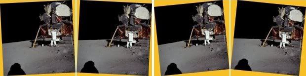 Tolerances of this size totally annihilate the foundation of your tilted horizon argument, as the tilt lies within these tolerances. According to the tilt of the photos 5928 and 5929 I did not say anything about the one or the other photo. I explicitly stated, that the photos are tilted relative to each other. Look at this: 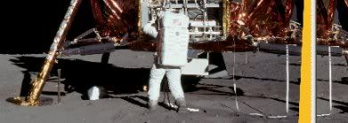 What you see here is to the right a part of 5929 and to the left a part of 5928, which is rotated 2,5 degrees. I do not intend to discuss whether the band is vertical or not, but the 2,5 degrees rotation is necessary to make the two bands parallel. I simply can't imagine, what kind of analysis, you have made to establish, that those two photos are "perfectly vertically aligned". Your applied tolerances render the conception meaningless. We don't know, what is absolutely perfectly horizontal or vertical, based on the given facts, but we don't need to know that either. What we do know, is that the camera is well below the visible horizon regarding the photos 5927-5929 as previously explained and demonstrated. |
|
