Post by threadworm on Mar 22, 2011 17:12:46 GMT -4
Thanks 
But wait...there's more:
Back in the 1960s, when weather satellites were a new toy, many people worked on matching orbital observations with those derived from ground based data such as radar.
One such researcher was the author of this 1971 MIT masters thesis:
dspace.mit.edu/bitstream/handle/1721.1/59623/30119849.pdf?sequence=1
The author looked at satellite images from the Caribbean's BOMEX dataset, and compared them with data from the ground.
Those satellite images cover the period of Apollo 11's flight.
Let's see what they produce:
This image (AS11-36-5361):
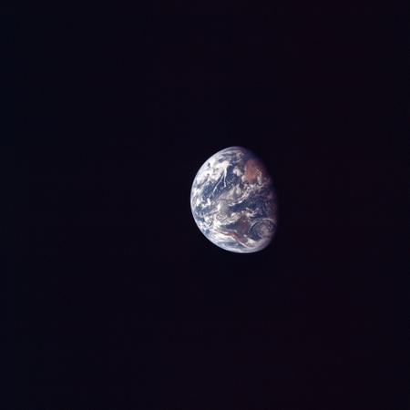
With the craft on the way to the moon having discarded the final Saturn stage and docked with the LM.
Here is an ESSA 9 satellite image of the Caribbean taken on July 17th:

(the annotations are the original author's)
The high resolution version of the apollo image allows us to zoom in on the Caribbean. We can then superimpose the satellite image on it:

On July 18th, roughly 55 hours into the mission, this photograph was taken (AS11-36-5381):
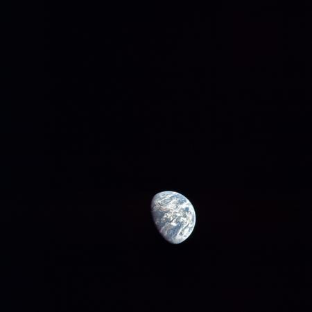
The remainder of this magazine show images Aldrin in the LM, and then the lunar surface.
Here is the ESSA 9 image of the Carribean for the 18th:

(the annotations are the original author's)
If we rotate the apollo image so that it is the right way up, then superimpose the ESSA 9 image we get this:

On the way home from the moon, Magazine 38 was used to take photographs of the receding moon and approaching Earth.
The first image of Earth on that magazine is AS11-38-568:

I'd put this image at half way home - the 22nd of July.
Here's the ESSA 9 image from that date:

(the annotations are the original author's)
and here is the superimposed ESSA/Apollo image.

You can draw your own conclusions as to how well these three sets of images match.

But wait...there's more:
Back in the 1960s, when weather satellites were a new toy, many people worked on matching orbital observations with those derived from ground based data such as radar.
One such researcher was the author of this 1971 MIT masters thesis:
dspace.mit.edu/bitstream/handle/1721.1/59623/30119849.pdf?sequence=1
The author looked at satellite images from the Caribbean's BOMEX dataset, and compared them with data from the ground.
Those satellite images cover the period of Apollo 11's flight.
Let's see what they produce:
This image (AS11-36-5361):
With the craft on the way to the moon having discarded the final Saturn stage and docked with the LM.
Here is an ESSA 9 satellite image of the Caribbean taken on July 17th:
(the annotations are the original author's)
The high resolution version of the apollo image allows us to zoom in on the Caribbean. We can then superimpose the satellite image on it:
On July 18th, roughly 55 hours into the mission, this photograph was taken (AS11-36-5381):
The remainder of this magazine show images Aldrin in the LM, and then the lunar surface.
Here is the ESSA 9 image of the Carribean for the 18th:
(the annotations are the original author's)
If we rotate the apollo image so that it is the right way up, then superimpose the ESSA 9 image we get this:
On the way home from the moon, Magazine 38 was used to take photographs of the receding moon and approaching Earth.
The first image of Earth on that magazine is AS11-38-568:
I'd put this image at half way home - the 22nd of July.
Here's the ESSA 9 image from that date:
(the annotations are the original author's)
and here is the superimposed ESSA/Apollo image.
You can draw your own conclusions as to how well these three sets of images match.


