lenbrazil
Saturn
Now there's a man with an open mind - you can feel the breeze from here!
Posts: 1,045
|
Post by lenbrazil on Feb 21, 2008 9:53:01 GMT -4
The relevance of this question to a CT will be revealed shortly.
If a plane is about 3 – 6 miles from its departure airport would we expect it to be on the exact published “initial true course” to its destination or might it for whatever reason be on a different one? If so how much of a variance, in degrees would be normal?
|
|
Al Johnston
"Cheer up!" they said, "It could be worse!" So I did, and it was.
Posts: 1,453
|
Post by Al Johnston on Feb 21, 2008 10:02:59 GMT -4
At 3-6 miles it would still be in the early stages of gaining height, so I'd have thought it rather unlikely to be heading for its destination at that stage: it would more likely be heading for the entry point to one of the controlled air corridors for crossing the country of origin. It won't be the same all over the World, but in Europe planes aren't permitted to fly just willy-nilly wherever the pilot feels like...
|
|
|
|
Post by JayUtah on Feb 21, 2008 10:50:04 GMT -4
If the plane is a large commercial airliner, 3-6 miles would still be negotiating departure airspace.
|
|
Ian Pearse
Mars
Apollo (and space) enthusiast
Posts: 308
|
Post by Ian Pearse on Feb 21, 2008 11:45:36 GMT -4
If the plane is a large commercial airliner, 3-6 miles would still be negotiating departure airspace. Yup, it would be flying the SID (Standard Instrument Departure) or similar published departure pattern. That may point it in the right direction, but unlikely. |
|
lenbrazil
Saturn
Now there's a man with an open mind - you can feel the breeze from here!
Posts: 1,045
|
Post by lenbrazil on Feb 21, 2008 15:38:19 GMT -4
It was a C-130 Cargo plane flying out of Andrews AFB.
Perhaps it was a coincidence but from the pilot's description I narrowed its heading to within about a 60 degree range. The "initial true course" indicated by AirNav is within that range.
|
|
Ian Pearse
Mars
Apollo (and space) enthusiast
Posts: 308
|
Post by Ian Pearse on Feb 21, 2008 15:43:55 GMT -4
Consider further the wind direction. Aircraft have to take off into the prevailing wind. A plane leaving Heathrow Airport to go to Amsterdam will take off in a westerly drection if that is where the wind is coming from. The plane then loops round to the north if it flying a CLN departure, then loops further until it is heading east. A few miles from the departure point it may still be heading north in the SID, a full 90 degrees from the course to it's actual destination.
|
|
lenbrazil
Saturn
Now there's a man with an open mind - you can feel the breeze from here!
Posts: 1,045
|
Post by lenbrazil on Feb 21, 2008 16:03:28 GMT -4
AirNav lists 3 “take-off procedures” the plane takes of runway with a: 10 degree heading and turns to 270 degree heading 10 degree heading and continues at that vector 10 degree heading and turns to a 50 degree heading www.airnav.com/airport/adw I listed them in order of their closeness to the ‘initial true heading” (302) can me assume that is the order of the likelihood they would be used? From what you guys are telling me it seems that no such assumption can be made. The pilot did say he was flying "north and west' which to me sounds like 295 - 335 |
|
|
|
Post by trevor on Feb 22, 2008 4:05:38 GMT -4
I think a C-130 would only be 2-3 minutes into flight at 3000ft (Andrew's Dept Altitude)at that point. What runway did he take off from?
|
|
lenbrazil
Saturn
Now there's a man with an open mind - you can feel the breeze from here!
Posts: 1,045
|
Post by lenbrazil on Feb 22, 2008 15:34:05 GMT -4
I think a C-130 would only be 2-3 minutes into flight at 3000ft (Andrew's Dept Altitude)at that point. What runway did he take off from? Andrews has two parallel runways with 10/190 degree headings. The AirNav site only shows departure plans to the north if we assume he was going to go to 270 or 302 can we safely assume he’d still be turning 3 – 6 miles out? |
|
|
|
Post by scooter on Feb 22, 2008 20:23:27 GMT -4
The departures (SIDS) work for any runway. The question would be what departure heading were they given ("on departure, maintain runway heading, c/m 5000"...or "on departure turn right heading 310" etc)
Once off the ground they go to Departure control who gets them initially set up on the SID route, then as they gain altitude, they go to Center for continuing the flight.
It all varies with the airport and the particular airspace.
edit...went to myairplane.com, input kadw. These are basically radar vector departures, so there is an unlimited number of possibilities for the departure. The controller gives the vectors as required.
edit again...assuming we're talking about the C130 headed for MN that morning, the pertinant information to ask is ...what was the routing...the vectors given in the departure would lead, in some fashion, towards the route, the high (or low) altitude airways filed. What was the departure runway, and the initial heading given? At what point did the DEP controller have him look for the high speed inbound? Where was he at the time? Was he vectored in that direction before the transcripts we read happened? Or away?
A lot of unknowns in the situation that morning.
|
|
|
|
Post by dumbtechie on Feb 25, 2008 19:58:52 GMT -4
The relevance of this question to a CT will be revealed shortly. Googling Andrews + C-130 + Minnesota makes it pretty clear.  |
|
|
|
Post by scooter on Feb 25, 2008 22:23:24 GMT -4
lenbrazil...
duh, I shoulda realized you weren't from the US. It seems much of the world uses SIDs that are runway specific. Each runway having particular routings after takeoff to get them heading the right direction.
In the US, for the most part, the SIDs are the same for any runway, just requiring the DEP controller to climb the flight and get him vectored to the first fix. The Andrews SIDs are strictly vectors, with no fixes. So whatever routing the plane took was under voice vectors from departure control. Being they were in his airspace, he could vector them about anywhere, within reason.
|
|
|
|
Post by PhantomWolf on Mar 14, 2008 1:26:53 GMT -4
Might be handy in this question 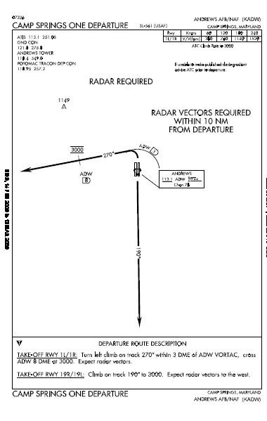 |
|
lenbrazil
Saturn
Now there's a man with an open mind - you can feel the breeze from here!
Posts: 1,045
|
Post by lenbrazil on Mar 26, 2008 13:33:15 GMT -4
lenbrazil... duh, I shoulda realized you weren't from the US. It seems much of the world uses SIDs that are runway specific. Each runway having particular routings after takeoff to get them heading the right direction. In the US, for the most part, the SIDs are the same for any runway, just requiring the DEP controller to climb the flight and get him vectored to the first fix. The Andrews SIDs are strictly vectors, with no fixes. So whatever routing the plane took was under voice vectors from departure control. Being they were in his airspace, he could vector them about anywhere, within reason. I'm not a foreigner who understands aviation, I'm an American (living in Brazil) who has learned a little about the subject from looking into CT's like the Wellstone crash and 9/11. SID I take it is "standard instrument departure" and DEP is "departure"? All- I was vague because I didn't want to suggest a correct answer. Ultimately what I wanted to know was the following. A C-130 took off from Andrews heading to Minneapolis at 9:30 on 9/11. The pilot said he had a view of the Mall (center of Wash D.C.) and was flying "north and west" when he spotted flight 77 incoming. This would have been only a couple of miles/minutes after take off. It seems he was, a least roughly, on the proper heading for his destination. But from the comments of people here I gather it was almost as likely he would have been heading in a different direction at that point than towards his destination. |
|
|
|
Post by PhantomWolf on Mar 26, 2008 17:18:53 GMT -4
The people you are arguing with likely get their info from P4T911, in other words a bunch of idiots. The Pilot says they when North and then west, the P4T group take this to mean due north and then due west. They also interpret "a good view of the mall" as "over the mall". Neither of these things are correct. The image I posted above is the Radar tracking of the flight, there are others if I can find them that show the exact flight path. In the end it boils down to JDX and the P4T bunch being morons who try and twist everything to fit their predetermined plots. The C-130 was south of the mall, not over the top of it and the pilot's description of his flightpath and 77's match with the radar path.
|
|